Advertisement

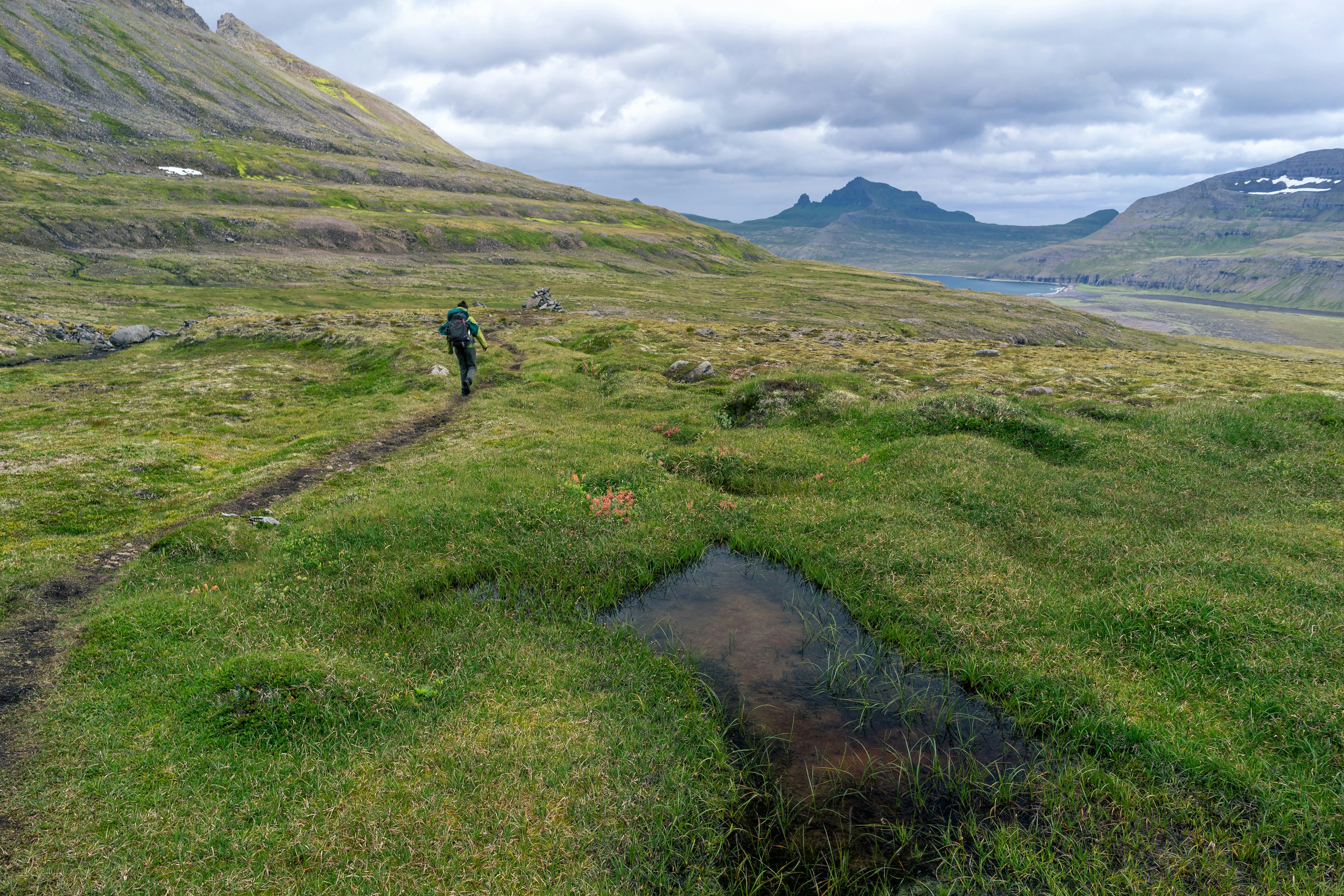
The Laugavegurinn. Sander van der Werf/Shutterstock
Few countries on earth issue such a pure call to explore the wild on foot as Iceland. This landscape т the ice, the lava fields, the gravel trails across grasslands т is best experienced with the ground underfoot and the wind (this being Iceland, itтs often a decidedly cold wind) in your hair.
Icelandтs hikes are a mix of shorter day or half-day walks, as well as multiday treks. The latter tend to be serious undertakings; youтll need to be self-sufficient, sleeping in mountain huts or your own tent, and we strongly recommend that you have a guide. But the benefits are limitless т itтs the best way to escape Icelandтs tourist crowds.
1. Svartifoss and beyond
Best for half-day hiking around Skaftafell
Distance: 5.3km (3.3 miles), 11km (6.8 miles) including SjУГnarnУpa
Estimated time to complete: 2 hours, 5 including SjУГnarnУpa
Level of difficulty: easy to moderate
Advertisement
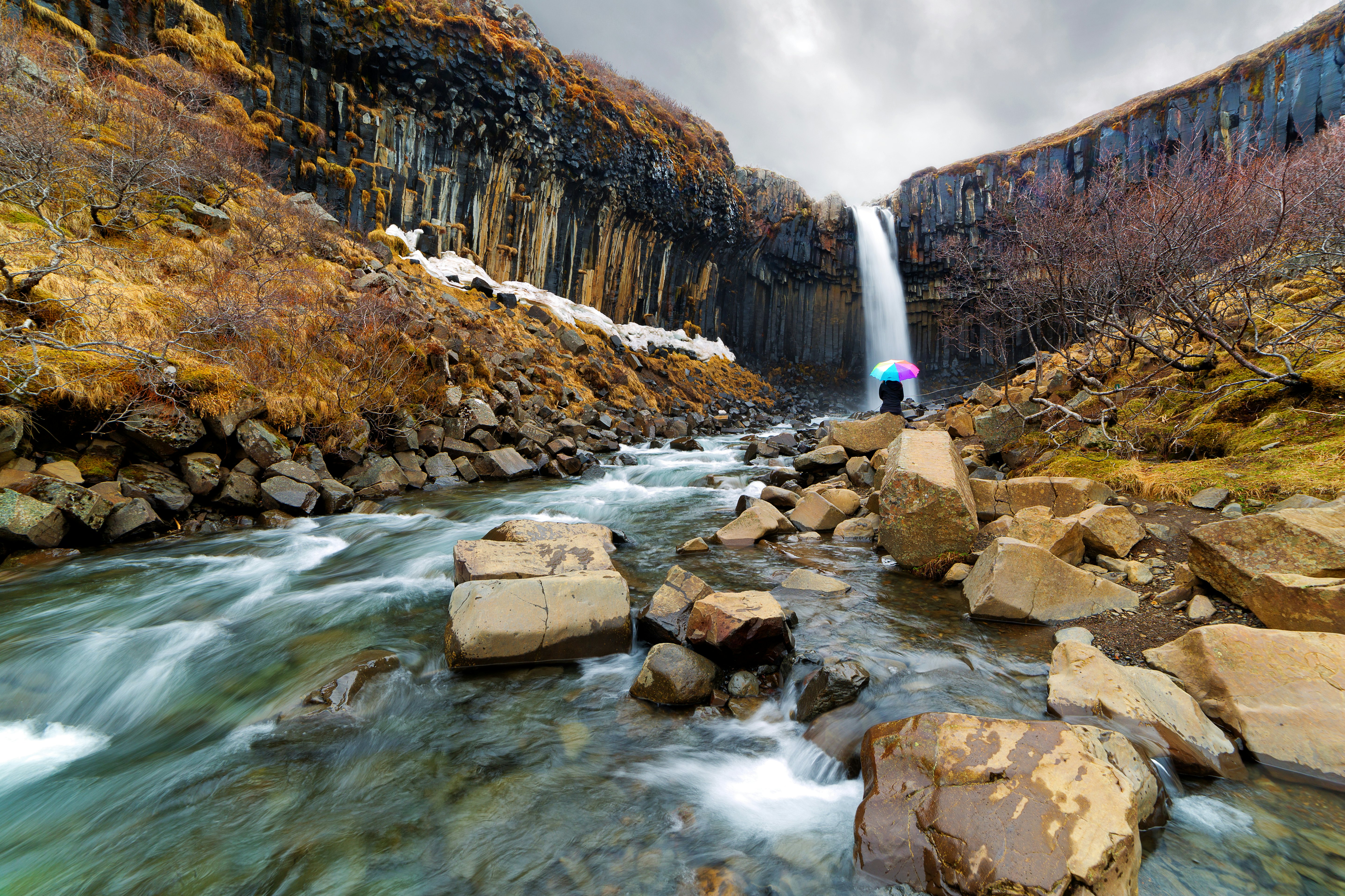
If we had to choose one hike that showcases Iceland in microcosm т and that almost anyone can do т weтd choose this Skaftafell treasure. Skaftafell is one of those places where the ГеВЙГйВдВЙТсУЖАьГмБєБє ice cap tumbles off the heights spectacularly close to the Ring Road, and this trail (S2) rises steadily into the foothills from the visitors center.
Even if youтve seen dozens of Icelandic waterfalls, you havenтt seen anything like Svartifoss. This brooding cascade crashes between black basalt columns formed in the distant past by the cooling and contraction of lava. On your return, if youтre feeling up to it, take the S6 trail т 11km (6.8 miles) return т which runs to SjУГnarnУpa, with its sweeping views over SkaftafellsjУЖkull.
Return to the S2 and, instead of retracing your steps to the visitors center, head west up the track to SjУГnarsker, where most hikers fall silent before the sight of SkeiУАarУЁrsandura. The vast plain formed by the gravel, silt and sand washed down by the lava from volcanoes past unfurls to the far horizon. On your way back to the coastal plain and visitors center, stop by Sel, a traditional turf-roofed farmhouse.
Planning tip: Parking costs 1040 Icelandic krУГnur (US$8.40) т pay at the machines in the parking lot or on the . You can also walk 3.7km (2.3 miles) to the tip or glacier snout of SkaftafellsjУЖkull from the visitors center in an hour.

2. Laugavegurinn
Best long-distance trail
Distance: 55km (34 miles)
Estimated time to complete: 2т5 days
Level of difficulty: challenging
The Laugavegurinn is like one long portal into another world. Stretching from Landmannalaugar to УУГrsmУЖrk, itтs a glorious hike, made easier by the presence of mountain huts at regular intervals along the route. But such practicalities are secondary to the sheer magnificence of this trail, which takes you past vividly colored rhyolite mountains and transparent glacier rivers, within sight of some of Icelandтs signature glaciers, and alongside geothermal springs т Laugavegurinn means "Hot Spring Road."
After a relatively easy start from Landmannalaugar, you pass the boiling, seething earth at StУГrihver and otherworldly fields of black-as-black obsidian. Beyond Уlftavatn, an unfolding glacial panorama includes sightings of pretty ВбУНАљЛхВЙБєВѕТсУЖАьГмБєБє and infamous EyjafjallajУЖkull, which managed to shut down air travel in Europe for a week in 2010. The trail encounters rivers т youтll have to ford at least one stream т and ends amid the wildflowers of УУГrsmУЖrk; inhale deeply all the way in.
Planning tip: months in advance. The Laugavegurinn usually opens in June and closes by mid-September (sometimes earlier).
3. BreiУАУЁrmУЖrk Trail
Best for glaciers and escaping the JУЖkulsУЁrlУГn crowds
Distance: 15.3km (9.5 miles)
Estimated time to complete: 4т5 hours
Level of difficulty: challenging
Everyone who visits Iceland finds the iceberg-filled lagoon of JУЖkulsУЁrlУГn and the glacier tongue of BreiУАamerkurjУЖkull irresistible. But we can count on one hand the number of travelers weтve met whoтve walked the BreiУАУЁrmУЖrk Trail. Apart from the beauty т and relative solitude т along the way, the benefits of this route include being one of the longest hikes possible in Iceland without crossing rivers, climbing precipitous mountain trails or mounting a major expedition (although bring plenty of water).
The path begins in JУЖkulsУЁrlУГnтs western lot and largely follows the point where the steep-walled mountains of Icelandтs interior meet the flat coastal littoral. Within the first half hour of the walk, you can suddenly hear the silence. The first stop, after 10km (6.2 miles), is BreiУАУЁrlУГn, one of the least-visited glacier-iceberg lagoon ensembles in Iceland. Further on, the hum of tourist traffic slowly returns as you approach ЙѓТсВЙБєБєВѕУЁАљБєУГВд, a quieter version of JУЖkulsУЁrlУГn, but by then the healing power of ringing mountain silence should have worked its magic.
Advertisement
Planning tip: Get a map of the route for 250kr (US$2) at the Skaftafellsstofa vistors center, which doubles as an information center for ГеВЙГйВдВЙТсУЖАьГмБєБє National Park, on the outskirts of KirkjubУІjarklaustur.
4. ЙѓТсВЙУААљУЁАљВЕБєТсУКДкГмАљ
Best for canyon views
Distance: 4km (2.5 miles)
Estimated time to complete: 1т2 hours
Level of difficulty: easy to moderate
It may be short, but the walk from the lower parking lot to the observation deck at the canyonтs summit is one of suspended anticipation. The steady but rarely steep ascent runs parallel to the main canyon, with the canyon on one side and a flower-strewn grassy hillside on the other. As you climb, there are glimpses of ЙѓТсВЙУААљУЁАљВЕБєТсУКДкГмАљтs magic: a window in one of the mysterious columns of rock that are such a feature of this place, a snatched vision of elemental blue waters, a green riverside far below.
But for the most part, ЙѓТсВЙУААљУЁАљВЕБєТсУКДкГмАљ keeps its secrets. Only at the very last minute, from the deck at the canyonтs highest point, does the full splendor reveal itself, with a view down through the defile, as if the landscapeтs interlocking pillars had been woven in stone. A waterfall, the streamтs glistening waters, the gasps of awe as each new traveler arrives т ЙѓТсВЙУААљУЁАљВЕБєТсУКДкГмАљ really does save the best until last.
Planning tip: For all the talk of the midnight sun, very few visitors see Icelandтs iconic landscapes bathed in the sepulchral half light of a summerтs evening т walk this route late at night and youтll find it blissfully free of fellow travelers.
5. Уsbyrgi to Dettifoss
Best for experiencing natureтs power
Distance: 37km (23 miles)
Estimated time to complete: 2 days
Level of difficulty: easy to moderate
In the north of Iceland, walking trails link two of the countryтs most significant attractions, taking you all the way through the stunning canyon of JУЖkulsУЁrgljУКfur (in the northern reaches of ГеВЙГйВдВЙТсУЖАьГмБєБє National Park).
The path begins at U-shaped Уsbyrgi, surrounded by cliffs 50m (164ft) high. Having explored what can feel like a lost world cut off from the rest of the country, stop by Уsbyrgi's GljУКfrastofa visitors center to pick up maps that will guide you south. But itтs difficult to get lost т the paths shadow the JУЖkulsУЁ river, taking you through cathedral-like spaces and the valley of Vesturdalur, a pristine place where, local legends assert, the rock pillars are trolls turned to stone when caught by the sunтs arrival. South of Vesturdalur at HУГlmatungur, the river channel narrows, creating roiling water and whirlpools. Then itтs on to the waterfalls of Hafragilsfoss. But theyтre nothing compared to the raw power of Dettifoss, Europe's most powerful waterfall.
Planning tip: Stick to the west bank of the JУЖkulsУЁ т the only bridge that crosses the river is near Уsbyrgi in the north, and itтs not possible to cross further south. Check the along the way.
6. Systravatn
Best for solitude and valley views
Distance: 5km (3.1 miles)
Estimated time to complete: 2 hours
Level of difficulty: easy to moderate
By the time youтve learned how to pronounce KirkjubУІjarklaustur like an Icelander, youтll have seen most of what there is to see in this small southern town т the striking stone-and-wood SteingrУmsson Memorial Chapel, built to honor its namesakeтs Eldmessa (Fire Sermon), which saved the town from lava in July 1783. Along this lonely stretch of the Ring Road, even KirkjubУІjarklaustur, home to fewer than 200 souls, can feel like a metropolis.
At the western end of town, the double waterfall of Systrafoss is a handsome cascade and the starting point of the climb out of the valley and up to Systravatn, a haunting high-altitude lake. Up here, you can smell the flowers, hear the birds and enjoy views that, when the sun is shining, can extend all the way to the ice cap of ГеВЙГйВдВЙТсУЖАьГмБєБє. Like any fabled place, it has a dark side too. According to local legend, two nuns drowned while bathing here after they watched a hand emerge from the lake adorned with a golden ring; when they reached for it, they were dragged into the depths.
Instead of returning via the same route, take the path down to АОБАљАьТсГмВЕУГБєДк, a natural rock formation that archaeologists once mistook for the ruins of a church.
Planning tip: SkaftУЁrstofa's visitors center sells maps and hiking guides to ГеВЙГйВдВЙТсУЖАьГмБєБє, including 10 walks in the KirkjubУІjarklaustur area.
7. Royal Horn (HornsleiУА)
Best for wild beauty
Distance: 80km (50 miles)
Estimated time to complete: 4т5 days
Level of difficulty: challenging
Imagine a place so wild that no roads reach it and you have to arrive by boat. Along the coast of the Westfjords in Icelandтs outer west, the Royal Horn (HornsleiУА) is a series of trails that offer a genuine wilderness experience along wild and windswept cliffs. This little-known hike takes you through the Hornstrandir Nature Reserve, a world of lonely fjords, emerald-green bluffs and swooping gulls, and easily the best place in Iceland to see an Arctic fox. Possessed of a stark and austere beauty, it is utterly unlike anywhere else in Iceland, and the route is a fabulous way to experience the natural drama of the Westfjords.
Rather than being just one hike, the paths out here can be as short as a day т take a tour out of УВѕВЙДкТсУЖАљУАГмАљ т or as long as five; the latter, the authentic Royal Horn, runs from VeiУАileysufjУЖrУАur to Hesteyri.
Planning tip: The visitors center in УВѕВЙДкТсУЖАљУАГмАљ can help with advice, practical information and maps, and it has a small exhibit on the Arctic fox. HornvУk and Hesteyri are the two main base camps, staffed by a lone ranger.
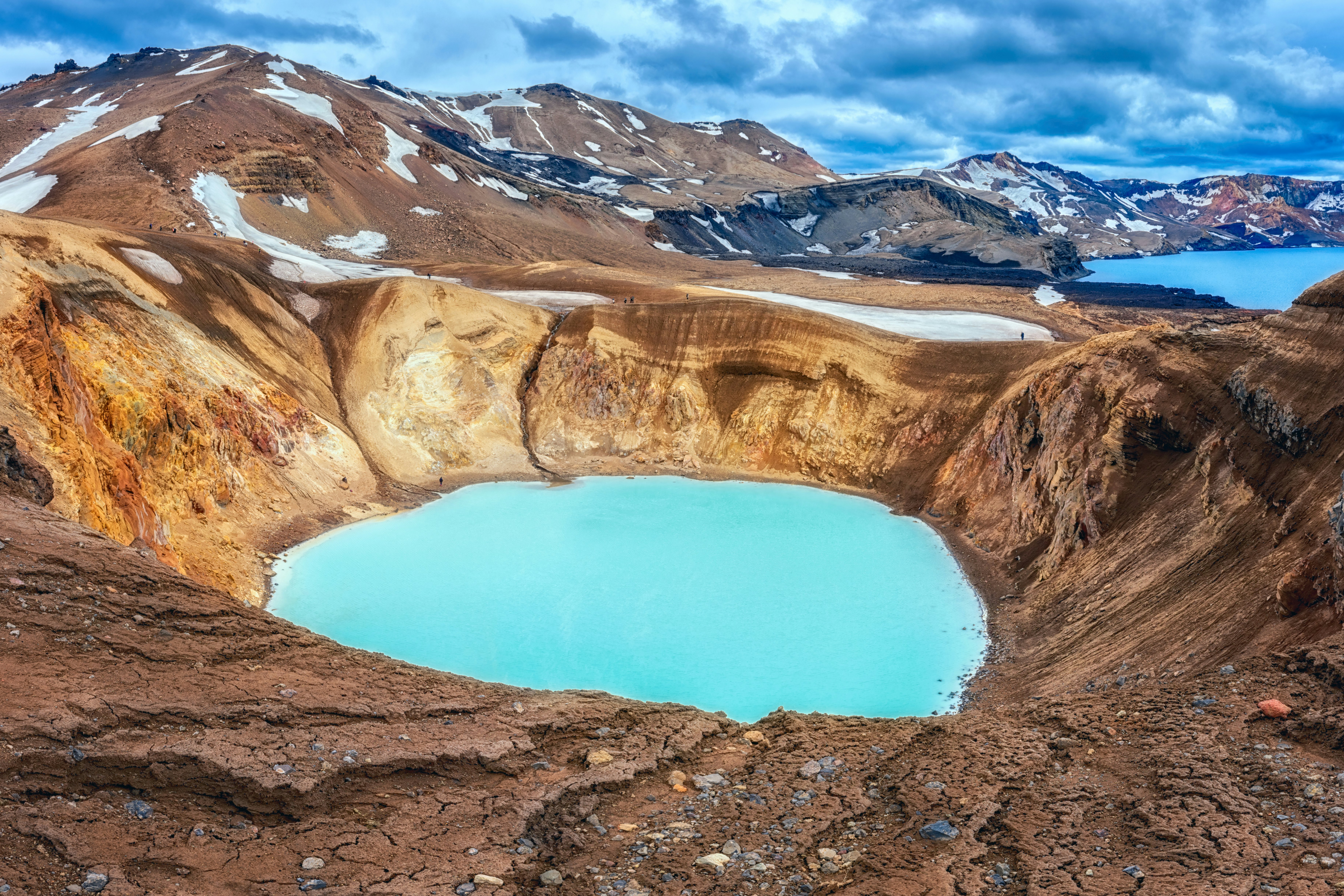
8. Askja Caldera
Best for volcanic splendor
Distance: 5km (3.1 miles)
Estimated time to complete: 2 hours
Level of difficulty: moderate to challenging
Youтre spoiled for choice when it comes to hiking the storied interior of Icelandтs Highlands region. Local legends from centuries past tell of fugitives and mythical creatures all across this sparsely inhabited realm where trails cross lava fields, climb volcanoes and spend time amid the lush oasis of HerУАubreiУАarlindir, with its green moss, angelica and the pinky-purple flowers of Epilobium latifolium (a type of evening primrose also called dwarf fireweed). You can even climb HerУАubreiУА, which Icelanders call Queen of the Mountains.
But weтve chosen the Askja caldera. Only a volcano could have created such a place. Unless youтve chosen to hike the 8km (5 miles) from the F910 from Drekagil, the trail begins at the main Askja parking lot. From there itтs a superb walk into and through the volcanic caldera. You crunch a lava field strewn with sienna and magenta stones to VУti, a vent that opened up during an eruption, causing a tephra crater that is now filled with geothermal waters. The cerulean waters of Уskjuvatn are usually swimmable т a truly surreal experience with awe-inspiring views.
Planning tip: The good folks at , Icelandтs highest altitude farm and just 8km (5 miles) off the Ring Road, run jeep and hiking tours, including to Askja and HerУАubreiУА, which are accessible only in a 4WD.
Tips for hiking in Iceland
Hiking in Iceland is usually only possible from June to September, depending on conditions. In some years, trails may open as early as May and stay open into early October, or they may not open until July and close in August.
Iceland is known for its potentially extreme weather, which change rapidly and without warning, even in summer. Come prepared for all conditions, and always notify someone before setting out on a longer hike.
Check for possible hazards at ; the SafeTravel app can help you send your GPS location to 112 emergency services.
Glacier hiking т which we donтt cover here т involves walking onto one of Icelandтs glaciers. Never attempt this on your own, and only undertake glacier hiking with an accredited guide and the necessary safety equipment.
Advertisement

Plan with a local